How To Find Your Property On FEMA’s Flood Insurance Rate Maps

What are FEMA flood maps?
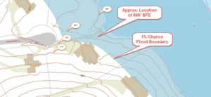
FEMA’s Flood Insurance Rate Maps (FIRMs) or just Flood Maps are provided after a flood risk assessment has been completed or updated for a community.  This study is known as a Flood Insurance Study.  The FIRM gives you the Base Flood Elevations (BFEs) and insurance risk zones in addition to floodplain boundaries.  The FIRM may also show a delineation of the regulatory floodway.

Once the “insurance risk zone”  (commonly referred to as the flood zone) is determined, actuarial rates, based on these risk zones, are then applied for newly constructed, substantially approved, and substantially damaged buildings.  FEMA uses these rates to determine the insurance rate you will pay for flood insurance

FEMA’s Digital Flood Maps

FEMA discontinued the production and distribution of paper flood maps in 2009 as part of its Digital Vision Initiative. This affected all the Flood Maps, boundary information, and study reports. However, clients can still view the products for free through their website or buy them in digital format.

To view these flood maps online, go to FEMA’s Map Service Center and key in your address (hi-lited area shown here) search for your home.  This will prompt you to then select the map that covers your area.  The Flood Maps are somewhat cumbersome to use online. It is best to go through the tutorial on the bottom right of the address search page for an easier and more effective use of the GIS map.
author avatar
Surveyor

More Posts

Land surveyor using a total station under an elevated highway during a boundary survey at a large infrastructure project site.
boundary surveying
Surveyor

The Infrastructure Boom Driving Boundary Survey Demand

Oklahoma City is about to change fast. With a $2.7 billion bond package set for a vote this October, hundreds of new projects are on the horizon—roads, bridges, drainage, and public buildings that will reshape the metro area for the next decade. Before the heavy machines roll out, one thing

Read More »
Surveyor using a total station to check property markers after an earthquake
boundary surveying
Surveyor

Do Quakes Shift Property Lines? Property Survey Insights

In late September, many people across Oklahoma City felt the ground rumble. A 3.7 magnitude earthquake struck near Prague, shaking homes and sparking plenty of “Did you feel it?” posts on social media. While the tremor didn’t cause major damage, it left homeowners wondering: could an earthquake shift your property

Read More »
Aerial survey view of storm-damaged neighborhood with visible roof damage and debris
land surveying
Surveyor

Why Aerial Survey Data Matters After Severe Storms

Oklahoma is no stranger to violent weather. From spring tornadoes to sudden summer downpours, storms here often leave behind more than just fallen branches. They can rip apart roofs, flood basements, and change the land itself. Just last week, strong winds tore the roof off a hospital in Sallisaw, forcing

Read More »
Surveyor using total station beside a city roadway during an ALTA Land Title Survey for infrastructure development
alta survey
Surveyor

How ALTA Land Title Survey Impacts Infrastructure Projects

If you live in Oklahoma City, you might have heard about the recent increase in ALTA land title survey contracts. But what exactly is an ALTA survey? Why are so many of these surveys needed now? And how does this affect the roads, bridges, and buildings we use every day? 

Read More »
Wooden stake labeled "Property Corner" marking the boundary line during a boundary line survey on a residential property with mountains in the background.
boundary surveying
Surveyor

How a $500 Boundary Line Survey Stopped a Land Grab 

Have you ever wondered how much land you really own? Sometimes, neighbors don’t see property lines the same way you do. That’s exactly what happened in a recent viral story about a $500 boundary line survey that stopped a neighbor from sneaking onto someone else’s land—and it captured the internet’s

Read More »
Severe backyard erosion near a property fence showing the importance of boundary surveys to protect land and property boundaries.
boundary surveying
Surveyor

Backyard Erosion Shows Why Boundary Surveys Are Essential

Backyard erosion may seem like a slow, quiet problem—until it’s not. In Oklahoma City, one family recently discovered a 15- to 20-foot drop forming along their backyard fence. What caused it? Drainage changes from a nearby street expansion. Now their property is at risk, repairs could cost over $100,000, and

Read More »