
land surveyor
Before You Call a Local Surveyor, Read This First
You’re getting ready to build a fence, add a driveway, or buy a property. At some point, you realize you need a local surveyor. That
You’re getting ready to build a fence, add a driveway, or buy a property. At some point, you realize you need a local surveyor. That

A recent fight over land along the Red River has been making headlines. The issue is between Texas and Oklahoma, and it all comes down
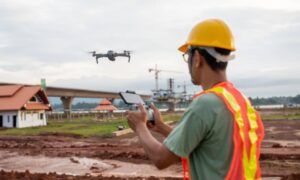
Drone mapping feels fast. A crew shows up, launches a drone, and gathers images in less than an hour. From the outside, it looks simple.